
Mount Borah
Statistics
- Date - 07/28/2001
- Elevation - 12,662'
- Route - Southwest Ridge
- Miles - 6.8
- Elevation Gain - 5,300'
- ACME Mapper - Link
- CalTopo - Link
- Partners - Not Applicable
Description
There are nine peaks in Idaho over 12,000', and Mount Borah is the tallest on the 12er list at 12,662'. One down, eight to go.
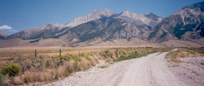
The main guide I used to scramble to the nine 12ers of Idaho is a book by Margaret Fuller entitled "Hiking Eastern Idaho". There is an entire section dedicated to driving, route, and trail directions of Idaho's 12,000' peaks. After moving to Boise, Idaho, I didn't waste anytime to travel over to eastern Idaho and climb Mount Borah in the Lost River Range. Mount Borah is mostly climbed by the southwest ridge route. Although non-technical, the standard route remains arduous and mentally demanding. The climb to the summit is not very difficult in terms of complexity, but is can be quite fatiguing due to the steepness of the slope. Idaho's highest peak is reached from U.S. Highway 93 by driving north of Mackay, Idaho, 21 miles or south of Challis, Idaho, 33 miles. There is a sign on the highway to indicate the direction towards the Mount Borah trailhead. No permits are required for climbing.
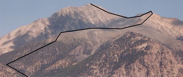
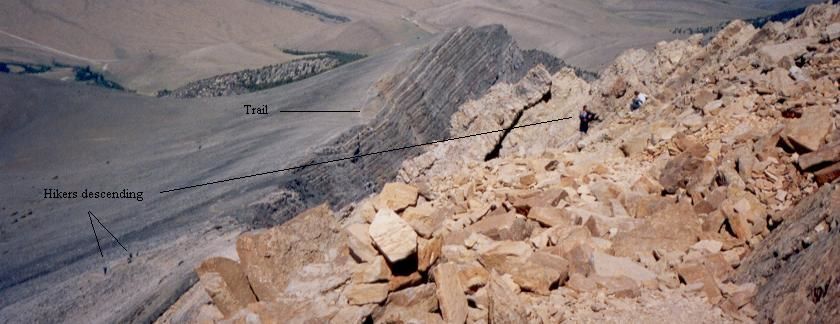
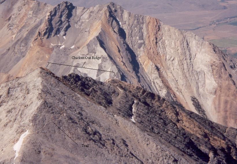
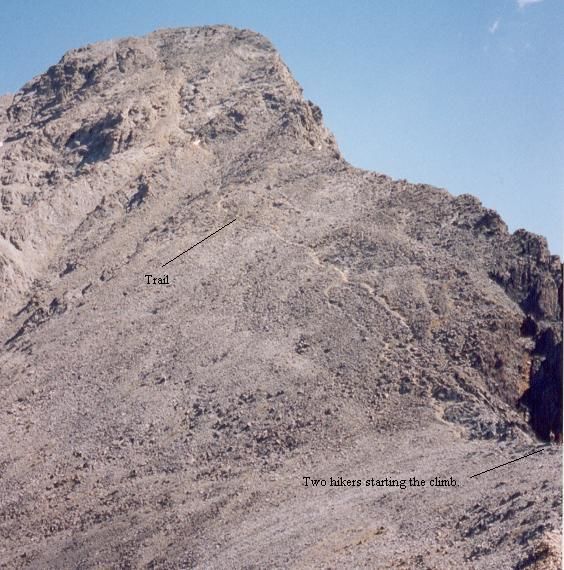
The beginning of the trail starts up a sagebrush/grass slope to the ridge. From here, the climbing really starts as the trail heads up the brutally steep west ridge of Mount Borah. Emerging above the timberline, the route continues to follow this ridge and is not quite as steep as the initial climb. After a short distance, you reach another steep portion which involves scrambling Chicken Out Ridge. This knife like ridge starts at approximately 11,300' and involves using both hands and feet to maneuver over and around the rocks. After this, continue to follow the ridge that crosses a steep couloir which is usually filled with snow. Finally, you curve around to the north and make the final ascent of 1,000' up the steep south ridge of Mount Borah.
Ideal climbing conditions range from early July through the middle of August when the snow pack is the lowest. It would be wise to keep up with current weather conditions as afternoon thunderstorms are common. In addition, you have to pack all of your water as there are no reliable water sources on the trail. Consider dropping a water bottle and your trekking poles off right before Chicken Out Ridge and picking them up on the way down. This lightens the load on the summit push and gives you a few less things to worry about during the most difficult section of the hike.
My initial plan was to climb a day earlier with Chuck Bauman of Boise, Idaho, and a friend of his, but this would have required me to depart on July 26th which is my wedding anniversary. Instead, I left Boise, Idaho, around noon on the 27th with the Trooper loaded with my hiking gear and a cooler full of food. After driving past the Craters of the Moon and making a few other stops, I arrived at the trailhead in the late afternoon. Surprisingly, Chuck Bauman and his friend were just finishing the descent and both of them were successful at reaching the summit. We visited over a couple of beers for an hour or so and then they returned home. I spent the evening reading, watching others finish the climb, and observing more vehicles enter the parking lot for the following days climb.
I got up around 6:30 and was on the trail about a half an hour later. I actually think I was one of the last to depart from the parking lot as many others got a much earlier start. I took a very slow and steady pace much like a tortoise, and I am very grateful for this. I noticed many others who attempted a faster speed which only required them to break more as they ran out of energy. As described above, the beginning wasn't too difficult until you reached the southwest ridge, which was the first test. After clearing the trees and reaching my first close up view of Mount Borah, I had a snack and took a quick break. From here, I headed southeast on the ridge over a more level section of the trail past one of the few camping sites available on the route. Shortly after this, the infamous Chicken Out Ridge was before me. There definitely were a number of exposed areas, but I simply took it slow and chose my holds wisely. I was held up by some kids in a few spots and just took the opportunity to rest rather than seek alternate routes.
Once past Chicken Out Ridge, the trail leveled off for a short section in order for me to regain myself for the final push. Unfortunately, I didn't have the beautiful weather that Chuck had on the previous day, and things were a bit cold and very windy. This last section to the summit was difficult and I could really feel myself being drained. No real distinct trail was evident as people were scrambling all over the south ridge. The use of your hands was required extensively on this section to the top, and although the summit was always in site, it never seemed to get any closer. I got to the point where I was forcing myself to take 25 steps before I would stop. With no clear route, it was much too easy to stop and think about where you were going next rather than keep going. I reached the summit after 4 hours and 5 minutes of hard work. It was well worth it and I felt as though it was a big accomplishment for me. The summit was fairly crowded as I snapped photos, took some video, and rested with a snack. I was tired, but felt as though I had not pushed too hard and was well-reserved for the descent.
The hike down wasn't as difficult as going up, but still a challenge. I only spent about 35 minutes on top before heading back down. The wind was picking up and I was thankful for the gloves and hat I packed along. I got back down the south ridge and Chicken Out Ridge fine, and it was then where I was feeling rather fatigued. In addition to the climb itself, the wind was taking its toll on me and I actually had to stop and brace myself a couple of times until the gusts died down. I made it down the ridge and back into the trees where I felt the end was in sight. My knees continued to take a beating as I made my way down and out of the wind. I finally made it back to the Trooper both excited and exhausted after descending for 2 hours and 40 minutes. I was really tired and crawled into my vehicle and headed home.
Photos
 Mount Borah
 Route
Route
 Looking down from the beginning of Chicken Out Ridge.
 Views to the southwest.
 Final section of the route to the summit.
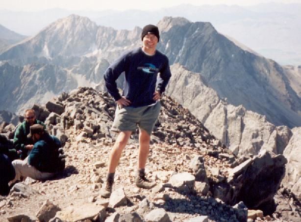 Summit Photo