
Mount Silverheels
Statistics
- Date - 01/29/2005
- Elevation - 13,822'
- Route - West Rige
- Miles - 5.4
- Elevation Gain - 3,430'
- ACME Mapper - Link
- CalTopo - Link
- Partners - Brian Kooienga
Description
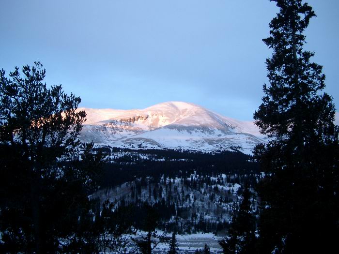
After missing the mild weather from the previous weekend and then reading multiple trip reports of what a great time everyone had in the mountains, I was determined to get out again. I contacted several friends and initially found someone interested. Brian and I considered an easy hike in the Front Range to Square Top Mountain, but shifted our attention to a more difficult Colorado Centennial Peak at the last minute. Mount Silverheels is the 96th tallest peak in Colorado and is located in the Ten Mile-Mosquito Range north of Fairplay, Colorado.
Brian and I met at The Fort Restaurant parking lot in Morrison, Colorado, at 5:30 and were hiking by 7:35. We identified Silverheels from Highway 285 on the drive and thought we were going to be in for a terrific day. It started out fine, but weather conditions deteriorated as we approached Beaver Ridge, and this ended up being a difficult hike for me.
It took approximately 1 hour and 15 minutes to reach the saddle on Beaver Ridge. After dropping approximately 400' and crossing Beaver Creek, the long ascent began. Gerry Roach comments in his guidebook that the size of Mount Siverheel's upper slopes may fool you, and that is exactly what it did. Add in the fact that visibility was limited made for the longest 2.7 miles I think I have ever hiked. I certainly underestimated this climb because of the apparent short distance required to hike it. Because of our inability to ever see the actual summit when hiking, we inappropriately assumed every rise and false summit was the top. This ended up being demoralizing, and at one point Brian even said that it was comical.
I accepted the first couple of false summits without too much trouble, but as they continued I started to doubt whether I would even make it because of the cold, snow, and winds. I was having difficulty with my hands, and Brian generously borrowed me his over mitts. On top of all of this, I was nauseated and getting a headache. Although I have never had problems at altitude, I blamed it on the elevation. We pressed on as the upper end of the west ridge eases a bit and finally made the summit at 11:00. Our digital camera batteries lasted long enough in the cold to get a couple of summit photos. There were limited views, so we simply ate and hydrated.
My head continued to bother me on the descent when it dawned on me that my blood sugar level was likely low. I asked Brian to accommodate multiple breaks so I could eat some food and treat my reaction. He obliged and by the time we returned to the trailhead at 1:35 I was feeling better. Despite the weather, we were happy with gaining approximately 1,000' an hour on the ascent. I slowed us down on the way out and we only gained an hour from on the way to the top. We carried our snowshoes to Beaver Ridge where we cached them. The only significant post-holing and trail-breaking we encountered was crossing Beaver Creek and some below tree line. There were three other people in the area that retreated well short of the summit of Mount Silverheels. This is a good candidate for a winter hike with easy trailhead accessibility.
Photos
 Mount Bross
 Mount Silverheels West Ridge
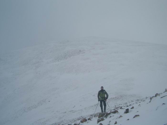 Brian
Brian Summit Photo
 Brian
Brian